| Introduction |
|
 With planning consent now agreed, there follows a detailed design stage during
which the conditions to the consent will need to be cleared and further work undertaken prior to
implementation. The staged build approach will mean that the waterway will initially support only
small boats (canoes, punts and open launches), but all new structures are being designed for up to
narrow boat standard, to allow larger boats to use the waterway as and when the necessary road bridge
works allow. The Waterway Framework Policy adopted by the council in 2009 already requires that any
new or rebuilt crossings over the channels must allow for sufficient headroom to eventually accommodate
narrow boats. Some road bridge changes are likely to be necessary as part of the Area Action Plan for
Maidenhead town centre which was adopted in 2011, with the Waterway included as one of five key projects.
With planning consent now agreed, there follows a detailed design stage during
which the conditions to the consent will need to be cleared and further work undertaken prior to
implementation. The staged build approach will mean that the waterway will initially support only
small boats (canoes, punts and open launches), but all new structures are being designed for up to
narrow boat standard, to allow larger boats to use the waterway as and when the necessary road bridge
works allow. The Waterway Framework Policy adopted by the council in 2009 already requires that any
new or rebuilt crossings over the channels must allow for sufficient headroom to eventually accommodate
narrow boats. Some road bridge changes are likely to be necessary as part of the Area Action Plan for
Maidenhead town centre which was adopted in 2011, with the Waterway included as one of five key projects.
Proposed Craft Size |
| Technical Design and Desk Study Results |
|
The initial technical design for the restored waterways was undertaken in
conjunction with expert consultants Black & Veatch, our Waterways navigation consultant Paul
Wagstaffe, MBE, and the Environment Agency which provided pre-application advice.
The design and environmental impacts were informed by a variety of professional studies, including
a River Corridor Survey, Tree and Bat surveys, plus a flood risk assessment developed using a
refinement of the Environment Agency's computer models of the local river area. Golder Associates
managed the overall Environmental Impact Assesssment supporting the planning application for Phase 1.
|
| Levels and Surveys |
|
 A study based on existing maps and records available to Black & Veatch was
completed some time ago and underpins the current plans and expected Phases of implementation.
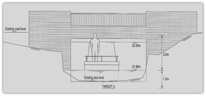
Design discussions focused on two alternative navigation standards for the waterway. Accommodating
narrow boats is the more demanding option, due to the minimum bridge heights and air draft required,
and some combination of the two standards is expected to be used along different parts of the route
to reduce the need for costly bridge works:
A study based on existing maps and records available to Black & Veatch was
completed some time ago and underpins the current plans and expected Phases of implementation.
Design discussions focused on two alternative navigation standards for the waterway. Accommodating
narrow boats is the more demanding option, due to the minimum bridge heights and air draft required,
and some combination of the two standards is expected to be used along different parts of the route
to reduce the need for costly bridge works:
A... narrow boats of up to 60 feet, or;
B... small boats such as punts, canoes and rowing boats.
C... It is unlikely that it would ever be feasible to cater for full size river
cruisers due to the headroom restrictions under many bridges
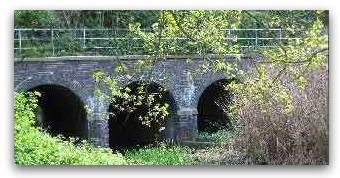
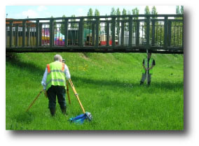
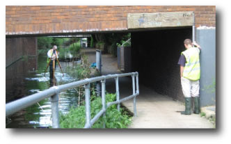 Specialist engineers completed a levels survey of the York Stream and Moor Cut (Maidenhead Flood
Relief Channel) sections of the planned waterways in 2006, in order to confirm bridge and river bed
heights, plus the stream widths and conditions at the various bridges that cross the current channels.
Specialist engineers completed a levels survey of the York Stream and Moor Cut (Maidenhead Flood
Relief Channel) sections of the planned waterways in 2006, in order to confirm bridge and river bed
heights, plus the stream widths and conditions at the various bridges that cross the current channels.
Further initial survey work was undertaken by MWRG members in 2006 to locate and establish the position of
outfalls that drain into the channel and would be affected by the raised surface water level proposed.
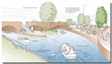
 The phase 1 waterways plan involves a combination of lowering the York Stream and Moor Cut channels (
by dredging), selective widening of the York Stream and raising the surface water levels via a lock and
weir at Green Lane. The resulting town centre 'Ring' will be 2.2Km long, 1.3m deep and a minimum 7.2m
wide (at the bed) in the two way sections. The 'Ring' will be connected via Bray Cut to the River Thames
by Bray Marina The phase 1 waterways plan involves a combination of lowering the York Stream and Moor Cut channels (
by dredging), selective widening of the York Stream and raising the surface water levels via a lock and
weir at Green Lane. The resulting town centre 'Ring' will be 2.2Km long, 1.3m deep and a minimum 7.2m
wide (at the bed) in the two way sections. The 'Ring' will be connected via Bray Cut to the River Thames
by Bray Marina
A canoe based survey by volunteers of the lower channel from Green Lane down to the River Thames. was
carried out in July 2008 and we also have the original Thames Conservancy drawings for the 1960s enlargement
works that formed part of the Pre-Jubilee River flood defence system for the area. Both show the lower
waterway is already quite substantial, the underlying channels there being up to 14 metres wide and over 1
metre deep. With quite minor work to remove obstructions, cut back overgrown trees and skimming of the
accumulated silt and mud banks, the waterway beneath Green Lane could quite easily be brought back into
use we believe.
|
| Long Sections |
|
All of the technical and outfall data acquired to date has been incorporated
into provisional engineering drawings of the proposed route as part of the Phase 1 planning application.
These include cross sectional drawings of the channel and bridges under which the stream passes, plus so
called " Long Sections" showing the gradient of the channel along its route. The latter were used to
assess alternative target water levels for the restored waterways, their impact on headroom and the
extent of bridge modifications needed.
|
| Programme |
|
The overall construction programme for the waterways will take some years to
implement and be paced by the necessary planning and other consents, plus inevitably our ability
to attract the funding required. Subject to funding, we are hopeful that Phase 1 - allowing small
craft around the town centre 'Ring' - can be completed around 2016 and that access below Green Lane
from the Thames will also by then have been improved. Construction of the lock will be progressed
only when the size and number of craft able to use the waterway require it. Later phases could
involve the extension of the waterway to the north of Maidenhead and would take a further few
years if considered feasible.
|